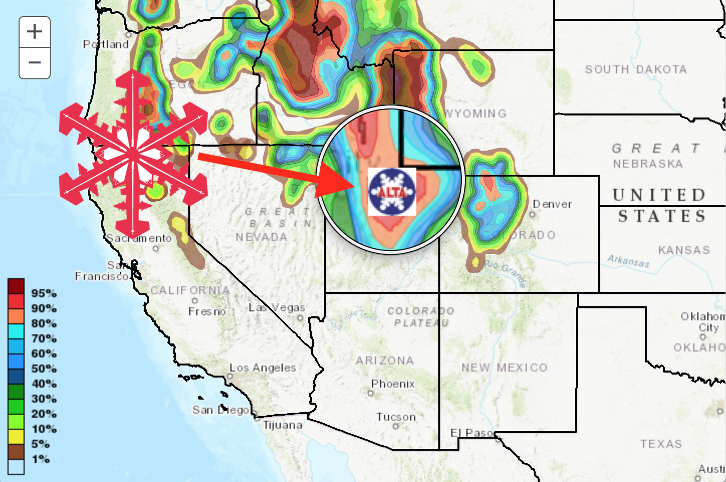
 NOAA is calling for up to 2 FEET of snow for Thursday through Friday this week at Alta Ski Area. Credit: NOAA 12/10/19
Brought to you by Alta Ski Area
"A Winter Storm Watch is in effect from Thursday afternoon through late Friday Night."NOAA is calling for 12-24" of snow to fall at Alta Ski Area, UT on Thursday and Friday. There's also potential for accumulating snow to continue across portions of the Wasatch Mountains into later Saturday and through the day Sunday.
- NOAA, Salt Lake City, UT, 12/13/19
NOAA is calling for some isolated locations to receive EVEN HIGHER amounts.
* WHAT...Heavy snow possible. Total snow accumulations 12 to 24
  inches with isolated higher amounts.-NOAA, SLC UT, 12/10/19
Last Sunday's snowfall in the Wasatch Mountains totaled 6-12 inches of snow (0.8-1.57 inches of water) according to The Utah Avalanche Center. Much of that storm had graupel and dense snow which has created fast, surfy riding conditions.
So far, every weekend of the 2019-2020 ski season has seen powder skiing at Alta, and it looks like the trend is only going to continue.
The Supreme Chair at Alta opened TODAY for the first time this season giving way to stashes and goods tucked away in Katherine's Bowl. With this next storm rolling in this weekend, the skiing ought to be damn good as new terrain is opening at Alta weekly!
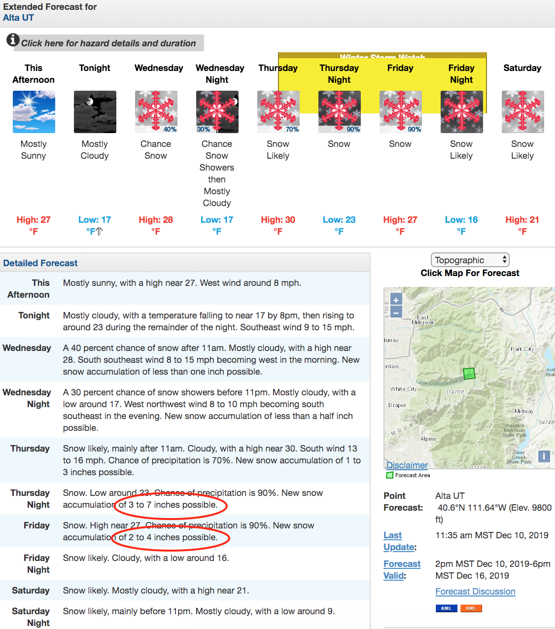
The extended 7-day forecast for Alta, UT. Credit: NOAA
Winter Storm Warning for Alta, UT
URGENT - WINTER WEATHER MESSAGE
National Weather Service Salt Lake City UT
223 PM MST Tue Dec 10 2019

UTZ007>010-110700-
/O.NEW.KSLC.WS.A.0009.191212T1900Z-191214T1200Z/
Wasatch Mountains I-80 North-Wasatch Mountains South of I-80-
Western Uinta Mountains-Wasatch Plateau/Book Cliffs-
Including the cities of Woodruff, Randolph, Alta, Brighton,
Mirror Lake Highway, and Scofield
223 PM MST Tue Dec 10 2019

...WINTER STORM WATCH IN EFFECT FROM THURSDAY AFTERNOON THROUGH
LATE FRIDAY NIGHT...

* WHAT...Heavy snow possible. Total snow accumulations 12 to 24
  inches with isolated higher amounts.

* WHERE...Wasatch Mountains I-80 North, Wasatch Mountains South
  of I-80, Western Uinta Mountains and Wasatch Plateau/Book
  Cliffs.

* WHEN...From Thursday afternoon through late Friday night. There
  is potential for accumulating snow to continue across portions
  of the northern mountains into later Saturday and potentially
  through the day Sunday.

* IMPACTS...Winter driving conditions can be expected across
  mountain routes of northern Utah starting Thursday afternoon and
  continuing into early Saturday morning.
No comments:
Post a Comment